
Characteristic of Peat Ecosystem Inventory (scale of 1:50,000)
- Inventory and Peat Ecosystem Function Determination 2015
In 2015, Directorate of Peat Deagradation Control, Directorate General of Pollution and Environmental Degradation Control, Ministry of Environment and Forestry has carried out the Peat Ecosystem Characteristics Inventory at the scale of 1: 50,000 in 5 priority peat hydrological units, which are located in parts of Aceh Province and West Kalimantan Province, as follows:
- Peat hydrological unit of Kampar River - Sungai Gaung, covers part of Pelalawan Regency, Indragiri Hulu and Indragiri Hilir, Riau Province;
- Peat hydrological unit of Sungai Gaung - Batang Tuaka River, covers part of Indragiri Hulu and Indragiri Hilir Regencies, Riau Province;
- Peat hydrological unit of Pulau Tebing Tinggi, covers part of Kepulauan Meranti Regency, Riau Province;
- Peat hydrological unit of Bengkalis Island, covers part of Bengkalis Regency, Riau Province;
- Peat hydrological unit of Sungai Kapuas - Terentang River, covers part of Kuburaya Regency, West Kalimantan Province.
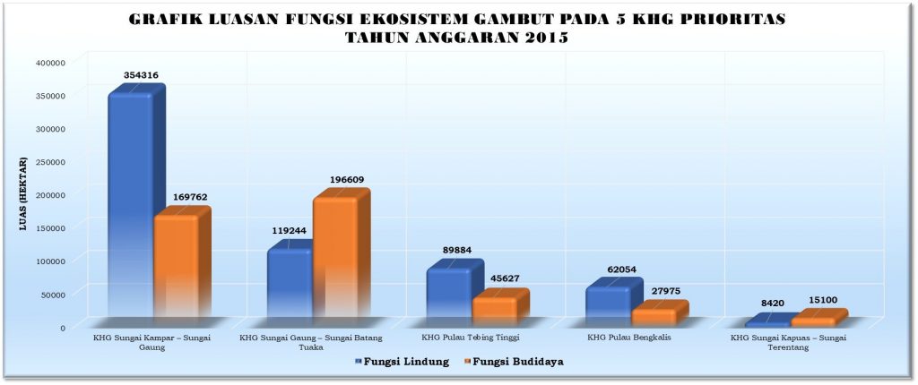
Figure 5. Area of peat ecosystem function in 5 priority peat hydrological units year 2015
Berdasarkan hasil Inventarisasi Karakteristik Ekosistem Gambut pada 5 (lima) KHG Prioritas Tahun 2015 tersebut dapat kita ketahui sebaran luasan Fungsi Lindung dan Fungsi Budidaya Ekosistem Gambut pada masing-masing KHG sebagai berikut :
- Peat hydrological unit of Kampar River - Sungai Gaung, has protection function covering 354,316 hectares or 67.6% of the total area of peat hydrological unit, and the cultivation function covering 169,762 hectares or 32.4% of the total area of peat hydrological unit;
- Peat hydrological unit of Sungai Gaung - Batang Tuaka River, has a protection function covering 119,244 hectares or 37.8% of the total area of peat hydrological unit, and the cultivation function covering 196,609 hectares or 62.2% of the total area of peat hydrological unit;
- Peat hydrological unit of Pulau Tebing Tinggi, has a protection function covering 89,884 hectares or 66.3% of the total area of peat hydrological unit, and the cultivation function of 45,627 hectares or 33.7% of the total area of peat hydrological unit;
- Peat hydrological unit of Bengkalis Island, has a protection function covering 62,054 hectares or 68.9% of the total area of peat hydrological unit, and the cultivation function of 27,975 hectares or 31.1% of the total area of peat hydrological unit; and
- Peat hydrological unit of Sungai Kapuas - Terentang River, has a protection function covering 8,420 hectares or 35.8% of the total KHG area, and the cultivation function covering 15,100 hectares or 64.2% of the total area of peat hydrological unit.
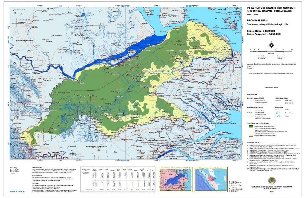
Figure 6. Map of peat ecosystem function in peat hydrological unit of Sungai Kampar – Sungai Gaung (scale of 1:50.000)
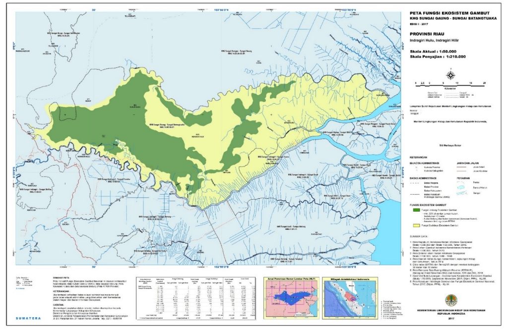
Figure 7. Map of peat ecosystem function in peat hydrological unit of Sungai Gaung – Sungai Batangtuaka (scale of 1:50.000)
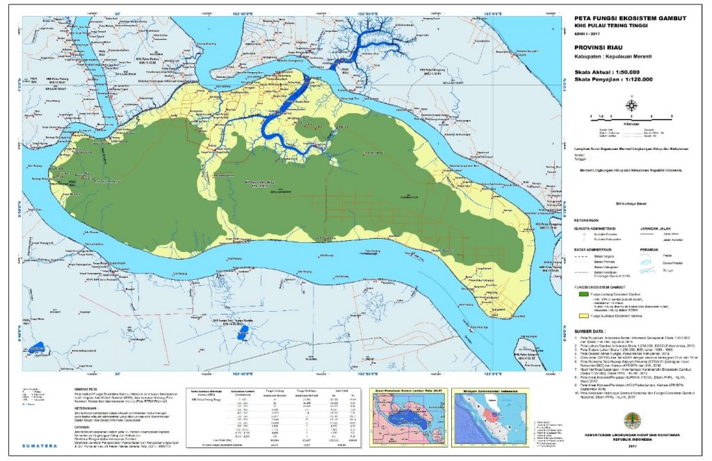
Figure 8. Map of peat ecosystem function in peat hydrological unit of Pulau Tebing Tinggi (scale of 1:50.000)

Figure 9. Map of peat ecosystem function in peat hydrological unit of Pulau Bengkalis (scale of 1:50.000)
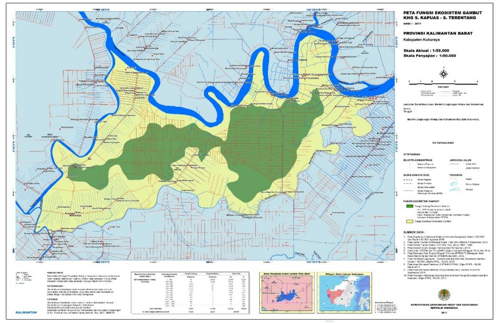
Figure 10. Map of peat ecosystem function in peat hydrological unit of Sungai Kapuas – Sungai Terentang (scale of 1:50.000)
- Inventory and Peat Ecosystem Function Determination 2016
In 2016, Directorate of Peat Degradation Control, Directorate General of Pollution and Environmental Degradation Control, Ministry of Environment and Forestry has carried out the Peat Ecosystem Characteristics Inventory at the scale of 1: 50,000 in 8 priority peat hydrological units, located in parts of Aceh, North Sumatra, West Sumatra, and East Kalimantan Provinces, as follows :
- Peat hydrological unit of Krueng Surin - Krueng Muling, Nagan Raya District, Aceh Province;
- Peat hydrological unit of Krueng Tripa - Krueng Seuneuam, Nagan Raya District, Aceh Province;
- Peat hydrological unit of Sungai Kanopan - Sungai Kuala, Labuhan Batu Utara Regency, North Sumatra Province;
- Peat hydrological unit of Sungai Kuala - Sungai Kuo, Labuhan Batu Utara Regency, North Sumatra Province;
- Peat hydrological unit of Aek Lunang - Aek Sidang, Pesisir Selatan Regency, West Sumatra Province;
- Peat hydrological unit of Aek Ubar - Aek Lunang, Pesisir Selatan Regency, West Sumatra Province;
- Peat hydrological unit of Sungai Kelinjau - Sungai Kedangyantau, Kutai Kartanegara and East Kutai Regencies, East Kalimantan Province; and
- Peat hydrological unit of Sungai Kedangyantau - Sungai Sabintulung, Kutai Kartanegara Regency, East Kalimantan Province.
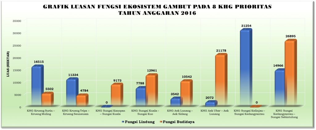
Figure 11. Area of peat ecosystem function in 8 priority peat hydrological units year 2016.
Based on the results of the peat ecosystem characteristics inventory in 8 priority peat hydrological unit, we find out the extent of protection function and cultivation function in each peat hydrological unit as follows:
- Peat hydrological unit of Krueng Surin - Krueng Muling, has a protection function covering 16,515 hectares or 75.0% of the total area of peat hydrological unit, and the cultivation function covering 5,502 hectares or 25.0% of the total area of peat hydrological unit;
- Peat hydrological unit of Krueng Tripa - Krueng Seuneuam, has a protection function covering 11,334 hectares or 70.3% of the total area of peat hydrological unit, and the cultivation function covering 4,784 hectares or 29.7% of the total area of peat hydrological unit;
- Peat hydrological unit of Sungai Kanopan - Sungai Kuala, has a protection function covering 0 hectares or 0.0% of the total area of peat hydrological unit, and a cultivation function covering 9,173 hectares or 100.0% of the total area of peat hydrological unit;
- Peat hydrological unit Sungai Kuala - Sungai Kuo, has a protection function covering 7,788 hectares or 37.5% of the total area of peat hydrological unit, and the cultivation function covering 12,961 hectares or 62.5% of the total area of peat hydrological unit;
- Peat hydrological unit Aek Lunang - Aek Sidang, has a protection function covering 3,542 hectares or 25.1% of the total area of peat hydrological unit, and the cultivation function of 10,542 hectares or 74.9% of the total area of peat hydrological unit;
- Peat hydrological unit Aek Ubar - Aek Lunang, has a protection function covering 2,072 hectares or 8.9% of the total KHG area, and the cultivation function covering 21,178 hectares or 91.1% of the total area of peat hydrological unit;
- Peat hydrological unit Sungai Kelinjau - Sungai Kedangyantau, has a protection function covering an area of 31,254 hectares or 100.0% of the total area of peat hydrological unit, and a cultivation function covering 0 hectares or 0.0% of the total area of peat hydrological unit;
- Peat hydrological unit Sungai Kedangyantau - Sungai Sabintulung, has a protection function covering an area of 14,966 hectares or 35.8% of the total KHG area, and a cultivation function covering 26,895 hectares or 64.2% of the total area of peat hydrological unit.

Figure 12.Map of peat ecosystem function in peat hydrological unit of Krueng Tripa – Krueng Seuneuam (scale of 1:50.000)
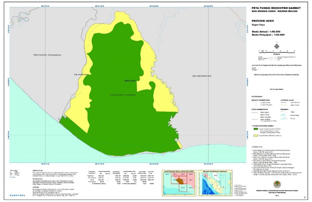
Figure 13. Map of peat ecosystem function in peat hydrological unit of Krueng Surin – Krueng Muling (scale of 1:50.000)
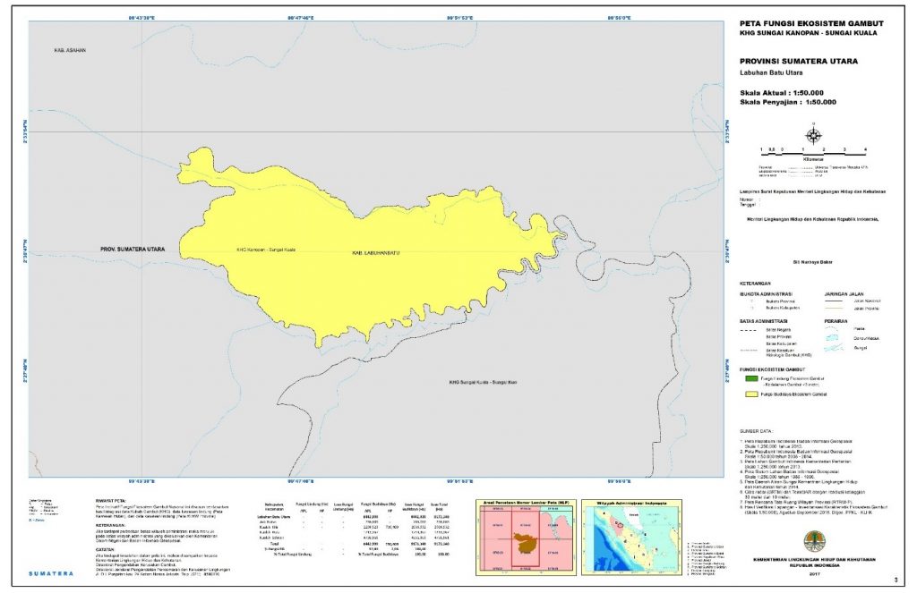
Figure 14. Map of peat ecosystem function in peat hydrological unit of Sungai Kanopan – Sungai Kuala (scale of 1:50.000)
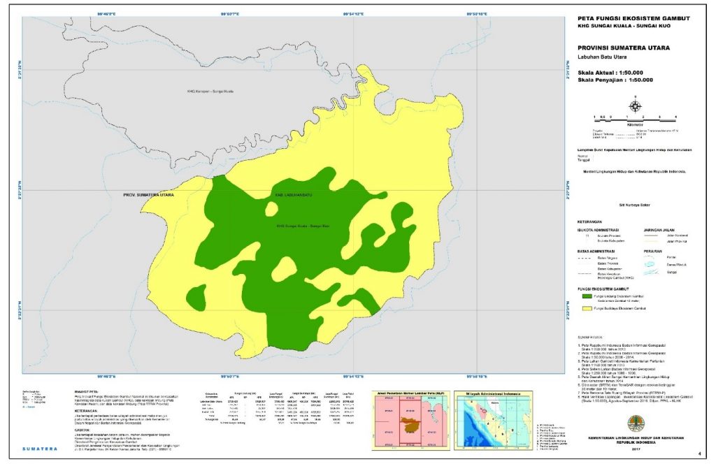
Figure 15. Map of peat ecosystem function in peat hydrological unit of Sungai Kuala – Sungai Kuo (scale of 1:50.000)
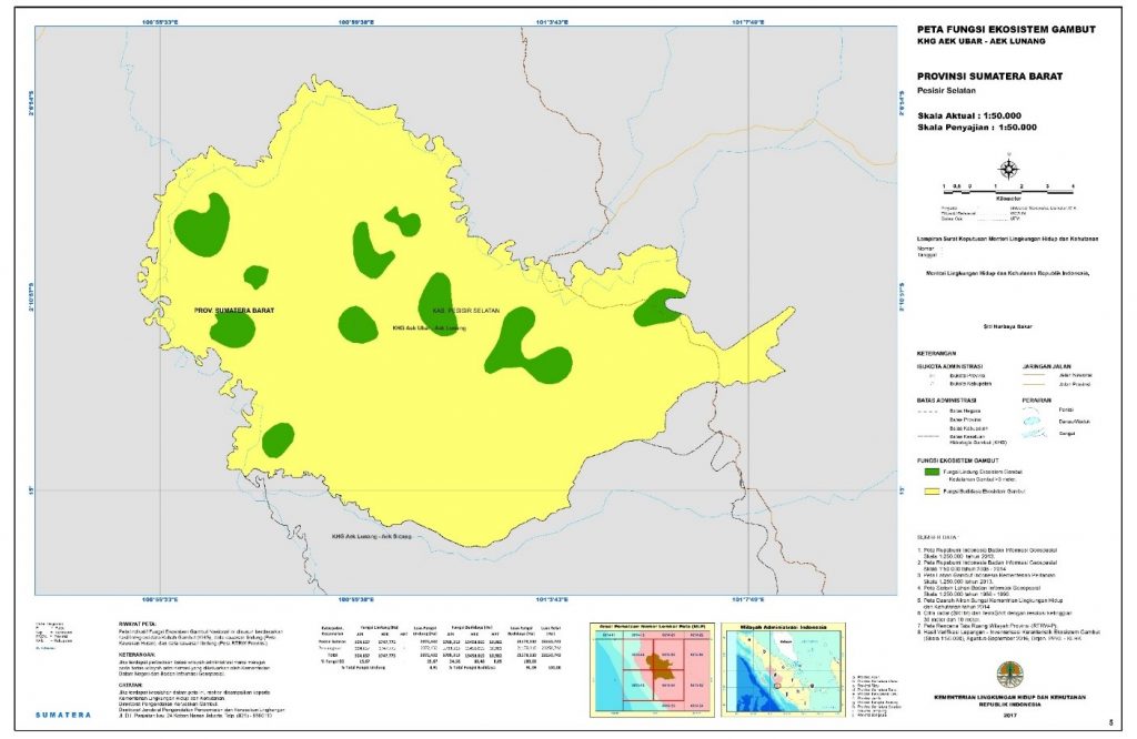
Figure 16. Map of peat ecosystem function in peat hydrological unit of Aek Ubar – Aek Lunang (scale of 1:50.000)
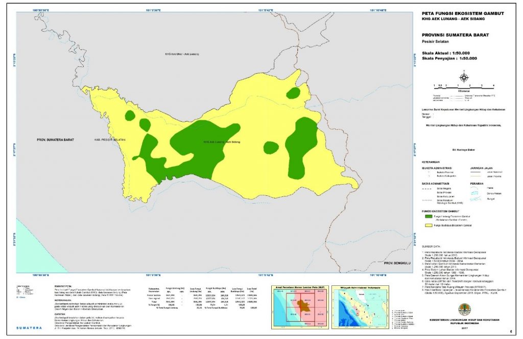
Figure 17. Map of peat ecosystem function in peat hydrological unit of Aek Lunang – Aek Sidang (scale of 1:50.000)
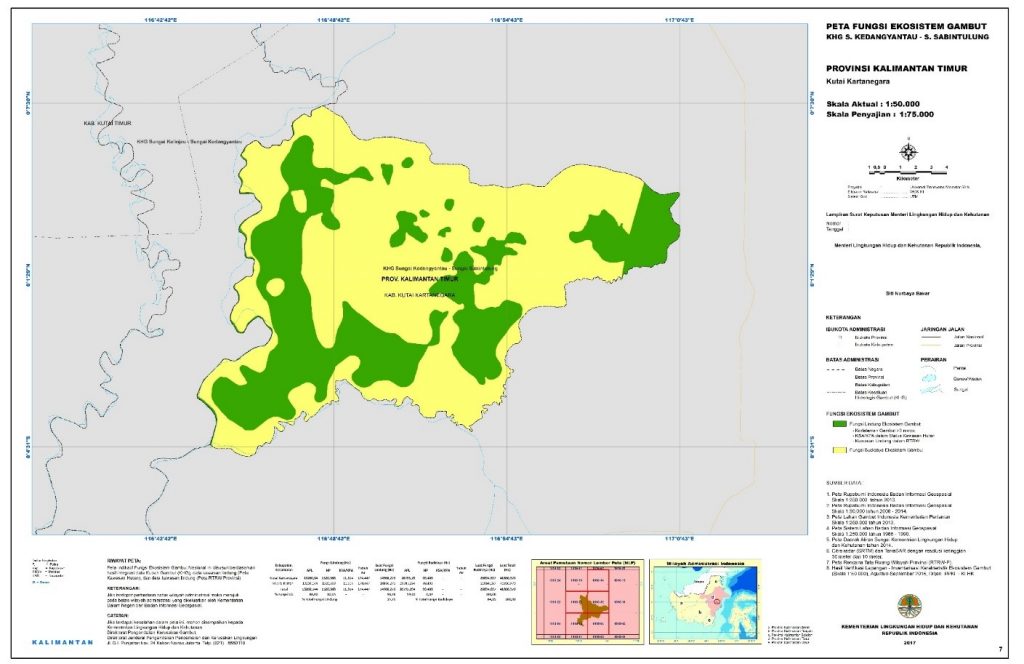
Figure 18. Map of peat ecosystem function in peat hydrological unit of Sungai Kedangyantau – Sungai Sabintulung (scale of 1:50.000)

Figure 19. Map of peat ecosystem function in peat hydrological unit of Sungai Kelinjau – Sungai Kedangyantau (scale of 1:50.000)
- Inventory and Peat Ecosystem Function Determination 2017
In 2017, Directorate of Peat Degradation Control, Directorate General Pollution and Environment Degradation Control, Ministry of Environment and Forestry has carried out the peat ecosystem characteristics inventory at scale of 1: 50,000 in 4 priority peat hydrological unit, which are located in parts of Aceh, North Sumatra and West Sumatra Provinces, as follows:
- Peat hydrological unit of Krueng Matee - Krueng Tumiyee, Nagan Raya District, Aceh Province;
- Peat hydrological unit of Batang Toru - Aek Maraitgadang, Mandailing Natal District, North Sumatra Province;
- Peat hydrological unit of Aek Maraitgadang - Aek Sikapas, Mandailing Natal District, North Sumatra Province; and
- Peat hydrological unit of Batang Ampu - Bah Mandiangin, West Pasaman Regency, West Sumatra Province.
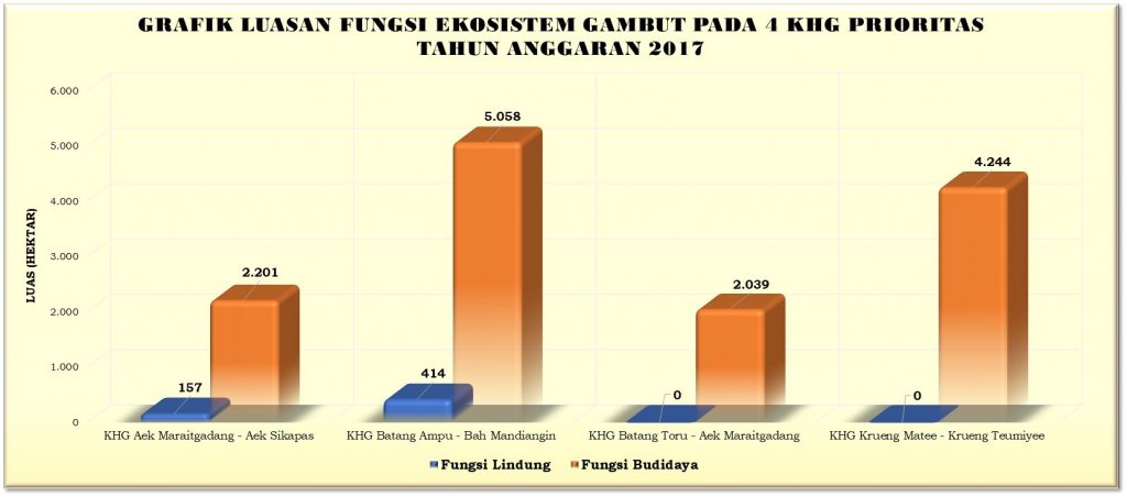
Figure 20. Area of peat ecosystem function in 4 priority peat hydrological units year 2017.
Based on the results of the peat ecosystem characteristics inventory in 4 2017 priority peat hydrological units, we find out the extent of protection function and cultivation function in each peat hydrological units as follows:
- Peat hydrological unit of Krueng Matee - Krueng Tumiyee, has a protection function covering area of 0.0 hectares or 0.0% of the total area of peat hydrological unit, and a cultivation function of 4,244 hectares or 100% of the total area of peat hydrological unit;
- Peat hydrological unit of Batang Toru - Aek Maraitgadang, has a protection function covering area of 0.0 hectares or 0.0% of the total area of peat hydrological unit, and the cultivation function of 2,039 hectares or 100% of the total area of peat hydrological unit;
- Peat hydrological unit of Aek Maraitgadang - Aek Sikapas, has a protection function covering 157 hectares or 6.64% of the total area of peat hydrological unit, and the cultivation function of 2,201 hectares or 93.36% of the total area of peat hydrological unit;
- Peat hydrological unit of Batang Ampu - Bah Mandiangin, has a protected function covering an area of 414 hectares or 7.56% of the total area of peat hydrological unit, and the cultivation function of 5,058 hectares or 92.44% of the total area of peat hydrological unit.
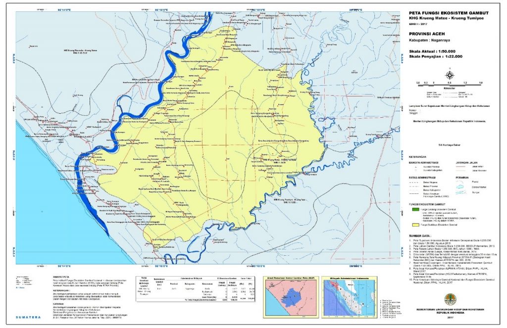
Figure 21. Map of peat ecosystem function in peat hydrological unit of Krueng Matee – Krueng Tumiyee (scale of 1:50.000)
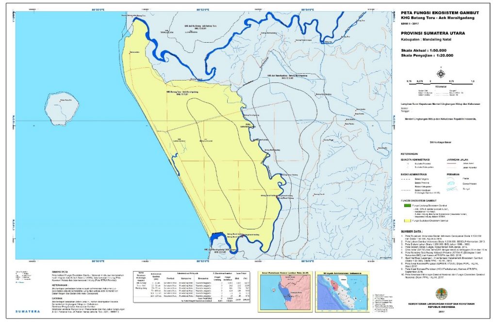
Figure 22. Map of peat ecosystem function in peat hydrological unit of Batang Toru – Aek Maraitgadang (scale of 1:50.000)
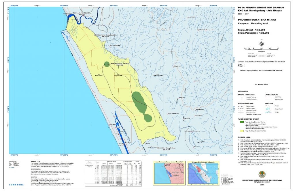
Figure 23. Map of peat ecosystem function in peat hydrological unit of Aek Maraitgadang – Aek Sikapas (scale of 1:50.000)
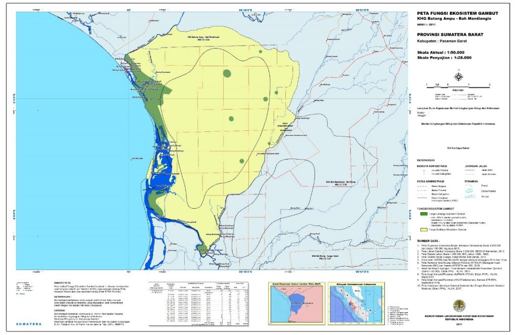
Figure 24. Map of peat ecosystem function in peat hydrological unit of Batang Ampu – Bah Mandiangin (scale of 1:50.000)