
Based on Indonesian Minister of Environment and Forestry Decree number SK.30/MENLHK/SETJEN/PKL.0/2/2017 concerning in determination of national peat ecosystem function map, Indonesia has 865 peat hydrological units with the total area is 24,667,804 Ha which can be divided into peat ecosystem protection function (12.398.482 Ha) and peat ecosystem cultivation function (12.268.321 Ha) (Figure 3). The detailed data of peat ecosystem function area in each province are shown in Table 2.
Tabel 2. Proportion area of peat hydrological unit in Indonesia.
| Province | Peat Hydrological Unit | Area Peat Ecosystem Function | Area | ||
| Protection Function | Cultivation Function | (Ha) | (%) | ||
| Aceh | 37 | 178.513 | 159.651 | 338.164 | 3,52 |
| Bangka Belitung | 17 | 57.264 | 40.649 | 97.913 | 1,02 |
| Bengkulu | 3 | 12.860 | 1.409 | 14.269 | 0,15 |
| Jambi | 14 | 549.601 | 354.822 | 904.423 | 9,42 |
| Kepulauan Riau | 5 | 5.104 | 11.179 | 16.284 | 0,17 |
| Lampung | 7 | 40.986 | 56.611 | 97.597 | 1,02 |
| Riau | 59 | 2.637.704 | 2.717.670 | 5.355.374 | 55,76 |
| Sumatera Barat | 14 | 78.056 | 75.803 | 153.859 | 1,60 |
| Sumatera Selatan | 36 | 1.191.082 | 910.679 | 2.101.761 | 21,88 |
| Sumatera Utara | 27 | 234.742 | 290.143 | 524.885 | 5,46 |
| Sumatera | 207 | 4.985.913 | 4.618.616 | 9.604.529 | 100,00 |
| Kalimantan Barat | 124 | 1.121.366 | 1.680.080 | 2.801.447 | 33,33 |
| Kalimantan Selatan | 4 | 81.882 | 156.583 | 238.465 | 2,84 |
| Kalimantan Tengah | 35 | 2.555.107 | 2.119.999 | 4.675.105 | 55,62 |
| Kalimantan Timur | 16 | 176.296 | 166.054 | 342.350 | 4,07 |
| Kalimantan Utara | 13 | 159.553 | 187.898 | 347.451 | 4,13 |
| Kalimantan | 190 | 4.094.203 | 4.310.614 | 8.404.818 | 100,00 |
| Sulawesi Barat | 2 | 19.682 | 22.794 | 42.476 | 67,01 |
| Sulawesi Tengah | 3 | 8.622 | 12.192 | 20.814 | 32,99 |
| Sulawesi | 3 | 28.305 | 34.985 | 63.290 | 100,00 |
| Papua | 250 | 2.708.311 | 2.388.966 | 5.097.276 | 77,46 |
| Papua Barat | 216 | 581.751 | 916.140 | 1.497.891 | 22,54 |
| Papua | 465 | 3.290.061 | 3.305.106 | 6.595.167 | 100,00 |
| INDONESIA | 865 | 12.398.482 | 12.269.321 | 24.667.804 | |
Source : Ditjen. PPKL-KLHK, 2017
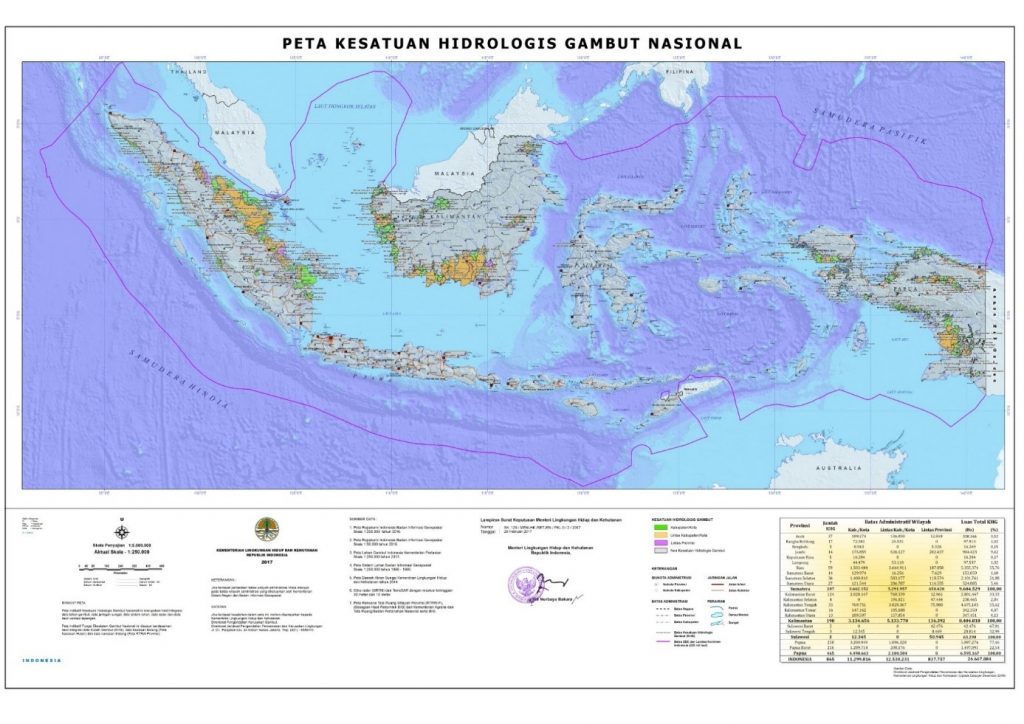
Figure 2. Map of National Peat Hydrological Unit (scale of 1:250.000)
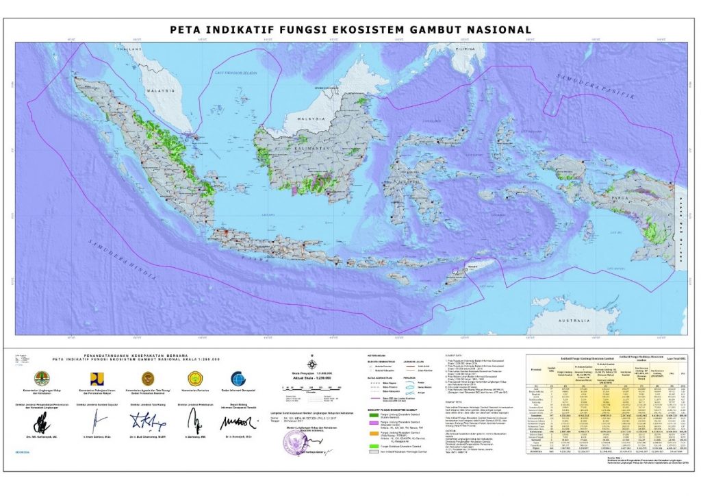
Figure 3. Map of National Peat Ecosystem Function (scale of 1:250.000)
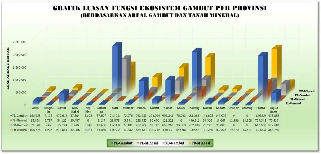
Figure 4. Graphic of peat ecosystem function area in each province (based on area of peat and mineral soil)
Description:
- FL-Gambut : Protection function with peat (based on BBSDLP-Ministry of Agriculture)
- FL-Mineral : Protection function with mineral soil (based on BBSDLP- Ministry of Agriculture)
- FB-Gambut : Cultivation function with peat (based on BBSDLP- Ministry of Agriculture)
- FB-Mineral : Cultivation function with mineral soil (based on BBSDLP- Ministry of Agriculture)